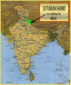
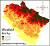
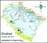
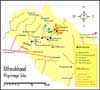
Geographic Information
13 Districts Comprise Uttarakhand
Kumaon:
Garhwal:
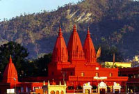
(Rediff) Hardwar Temple
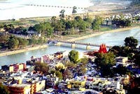
(Rediff) Bridges over the Ganga
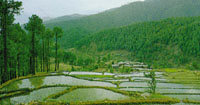
(DV) Terai Rice Paddies
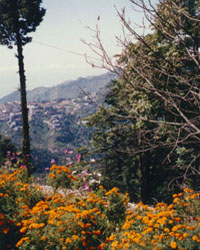
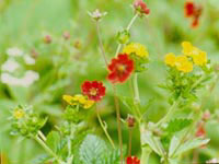
(NR) Flowers of Mussoorie
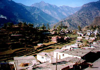
(RN) Chamoli Town
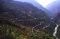
(Rediff) Roads in the Middle Himalaya
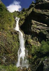
(VB) Descent
(Rediff) Flowers in the High Himalaya
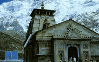
(VB) Kedarnath Temple
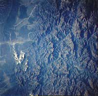
(Earthrise) Alaknanda from space
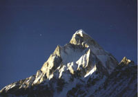
(HV) Shivling
(VB) Glaciers
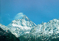
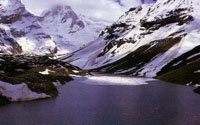
(UNESCO) Nanda Devi
 |
 |
 |
|
|
|
|
Physiology
Garhwal and Kumaon, the two main cultural and political divisions of Uttarakhand, can be divided into three physiological zones that span the full breadth of the central Himalayas:
1 - Northern Zone: Making up much of Uttar Kashi, Chamoli, and Pithoragarh districts, this range begins at 3000 metres and proceeds steeply at places to as high as 7600 metres.
2 - Mid Zone: Proceeding from southern Uttar Kashi through Tehri, Chamoli, Almora, and Pithoragarh, here the slope rises to heights of 2000 to 3000 metres.
3 - Southern Zone: Merging with the adjoining Terai, this area includes Dehra Dun, southern Garhwal (Pauri), and Nainital at around 600 to 2000 metres above sea level.
Highest Peaks
- Nanda Devi (7,816 m)
- Chaukhamba (7,138 m)
- Satopanth (7,075 m)
- Trisul (7,045 m)
- Kedarnath (6,940 m)
- Kamet (6,883 m)
- Neelkanth (6,596 m)
River Systems
- Yamuna - Tons
- Bhagirathi - Bhilangana
- Alaknanda - Mandakini / Pindar / Nandakini / Saraswati / Dhauliganga
- Ramganga
- Kosi
- MahaKali - Sarju / Gori / Dauli
Vegetation
- Himalayan Cedar (deodar)
- Himalayan Blue Pine (chir)
- Oak (banj)
- silver fir, spruce, chestnut, elm, poplar, white birch, silver birch, yew, cypress. rhododendrons
grassy slopes begin
banj oak, rhododendron in abundance
banj, rhododendron give way to pine
haldu, tun
Forests - From Low to High Altitude
Tropical Deciduous
- Moist Siwalik Sal (Dehradun), Moist Bhabar Sal (Ramnagar, Haldwani)
Tropical Dry Deciduous
- Dry Siwalik Sal (dry exposed slopes), Dry Mixed Deciduous, Dry Bamboo Brakes (lower foothills), Khair Sissoo (along streams)
Sub-Tropical Pine
- Lower Siwalik Chir Pine, Upper Himalayan Chir Pine (above 2000m)
Sub-Tropical Dry Evergreen Scrub
- Olea Scrub (lower western hills), Upper Himalayan Chir Pine (above 2000m)
Himalayan Moist Temperate
- Lower Temperate, Moru Oak, Moist Deodar (Himalayan cedar), Temperate Mixed Coniferous, Temperate Moist Mixed Deciduous, Kharsu Oak, Oak-fir, Cypress, Alder, Blue Pine, Dry Temperate Coniferous, High Dry Blue Pine, Dry Juniper
Sub-Alpine
- Sub-Alpine High Fir, Sub-Alpine Birch-Fir
Moist Alpine Scrub
- Birch-Rhododendron Scrub, Deciduous Alpine Scrub, Dwarf Rhododendron Scrub
- Dry Scrub, Dwarf Juniper Scrub
Dry Alpine Scrub
Prominent Places
Pilgrimage Spots
Reptiles
Mammals
Birds