![]()
Updated: 5.31.03
These maps were derived from various different sources including:
Joshi, S.C., Joshi, D.R. and D.D. Dani. Kumaun Himalayas: A geographic perspective on resource development. Naini Tal : Gyanodaya Prakashan, 1983.
Kharkwal, S.C. 1977. Geographic Personality of Garhwal. The Himalaya. 1(1):3-13.
Singh, T.V. 1977. Opening Garhwal for Tourism: Towards Research-Based Planned Development. The Himalaya. 1(1):44-51.
Chandola, K. Across the Himalayas through the Ages: A Study of Relations Between Central Himalayas and Western Tibet. New Delhi: Patriot Publishers, 1987.
Dehra Dun Guide Map 1:20,000 (2nd edition). Dehra Dun: Survey of India, 1982.
CorelDraw 7.0, Adobe Photoshop 6.0, and Adobe Illustrator 9.0 were used in their creation.
- Rajiv Rawat
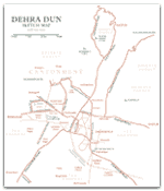 Sketch Map of Dehra Dun (1000x1175, with river beds)
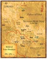 The Trans-Himalayas in Medieval Times (650x800)
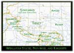 Himalayan Regions and Kingdoms (500x360)
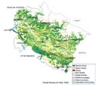 Forest Cover of Uttaranchal State (FSI, 1999) (700x600)
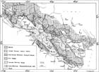 Geological Map of Central Himalayas (1000x725)
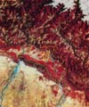 Aerial Photograph of Doon Valley (500x593)
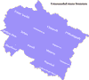 New District Map (large 1250x1175)
Please note that the maps below were sketched in 1998, before the present boundaries of Uttaranchal state were defined to include Hardwar District and before the boundaries of the new districts of Rudraprayag, Bageshwar, Champawat, and Udham Singh Nagar were defined. They cannot be taken as authoritative.
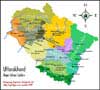 City & District Map (med 500x450, large 1000x900)
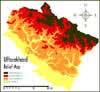 Relief Map (med 500x460, large 1000x920)
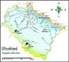 Geo Map (med 500x450, large 1000x900)
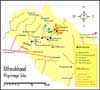 Religious Map (med 500x450, large 1000x900)
![]()